
Greenland Internship
StudentNow | Features | Shopping | Travel | Jobs | Research | Fun | Life | Sports | Colleges
| Travel Center |
| Travelocity Links |
| Discount Travel |
| Travel Bookstore |
| General Services |
| Guides & News |
| Maps |
| Currency Converter |
| Destinations: |
| Amsterdam |
| Travel Suggestions |
| Travel Magazines |
| StudentNow |
|
Continued: Student
Journalist Experience in Greenland
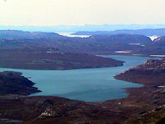
"The accumulation rate is one of the most important experiments that is required for the model to see what the contribution of the ice sheet is to sea level rise," he said. The plane we flew in was a P-3 Orion, a former submarine hunter built by the United States Navy and later purchased by NASA. Instead of torpedoes, the bomb bay underneath the plane now carries scientific equipment, and instead of flying over oceans searching for enemy subs, it now flies over ice gathering scientific data. Getting ready to fly each day took several hours of work, and on flight days everyone was up early. No one was up at the crack of down, though, because there was no dawn. It never got dark, a phenomenon that was almost eerie at first. No matter the time of day, I never noticed a change in the light, only a change in the position of the sun. The inside of the plane was stripped of anything unnecessary and loaded with lasers, global positioning systems, radar equipment and computers. A few seats were bolted to floor, but they looked almost out of place beside the hardware. This was no commercial airline, and neither was the safety briefing I received before my first flight. Pilot Chris Pali showed me how to operate the emergency escape door and use the two types of emergency breathing systems, in case of a cockpit fire. He pointed out the emergency escape rope and the ax that could be used to chop through the skin of the airplane for escape, and he explained how to use the rescue flares and signal mirror. And, should we be stranded on the ice, everyone on board had his or her own winter survival kit, complete with parka and boots. I simply nodded and clutched my camera. Pali told me that if I started to black out, I should tell one of the pilots. I agreed that I would certainly do this. The surface was sometimes soft and hazy, and sometimes jagged and sharp, ridged with huge crevasses that split the surface. Sometimes we were so far out on the ice sheet that it spread to the horizon in every direction, and other times we skimmed over glaciers dropping icebergs into the icy water. "Glaciers are drainage points for the ice sheet," Krabill said. At one point, we flew into a bank of clouds, and it was so hazy that the horizon disappeared and we were swimming in a thick fog of white. Near the edge of the ice where it was melting, pools of bright blue water would form on the surface. The ice was so white it hurt my eyes. To maximize the potential of the trip, several projects were taking place on the plane. Besides the two KU radars, other scientists were operating a global positioning system that was constantly tracking the position of the plane and a laser altimeter that was measuring the surface elevation of the ice. The radar that maps the internal layers of the ice, designed by Kanagaratnam the doctoral student, is used to determine the accumulation rate of snow on the ice. Little snow melts this far north, so each year's snowfall compresses the previous year's accumulation and forms layers in the ice, each one a little denser than the one above it. The accumulation rate lets scientists determine the mass balance of the ice sheet and see if the ice is growing or shrinking. The second radar, which measures ice thickness, penetrates to the bedrock beneath the ice. Torry Akins, a KU graduate and research scientist on the trip, said the ice is sometimes two or three kilometers thick. "If you know how thick the ice is, you can know how much ice is flowing past a certain point," he said. |
||
 By
Eve Lamborn
By
Eve Lamborn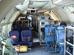 In
the mornings, Bill Krabill, a NASA senior scientist, would check
the weather forecast at the airport and plot the plane's course.
The scientific equipment won't work in cloudy weather. Meanwhile,
the flight crew would warm up the engines and fuel the plane, and
the scientists would prepare the equipment. My job was to stay out
of the way and take pictures.
In
the mornings, Bill Krabill, a NASA senior scientist, would check
the weather forecast at the airport and plot the plane's course.
The scientific equipment won't work in cloudy weather. Meanwhile,
the flight crew would warm up the engines and fuel the plane, and
the scientists would prepare the equipment. My job was to stay out
of the way and take pictures.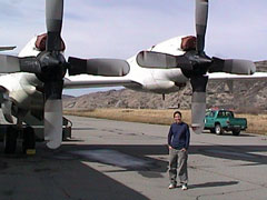 I
got to sit in the cockpit for the premium view of the spectacular
scenery. We flew low, 1,600 meters, and the flight pattern was mapped
out beforehand. Every mission took the plane to a new part of the
ice sheet. Sometimes we flew in a grid, and sometimes we flew a
circular route, from point to point. Each mission lasted between
five and eight hours, with the equipment gathering data about the
ice below the entire time.
I
got to sit in the cockpit for the premium view of the spectacular
scenery. We flew low, 1,600 meters, and the flight pattern was mapped
out beforehand. Every mission took the plane to a new part of the
ice sheet. Sometimes we flew in a grid, and sometimes we flew a
circular route, from point to point. Each mission lasted between
five and eight hours, with the equipment gathering data about the
ice below the entire time.StudentNow | Features | Shopping | Travel | Jobs | Research | Fun | Life | Sports | Colleges
©1996-2010 COPYRIGHT StudentNow - click for information other notices.
